Pushing Intelligence to the Edge: Satellogic’s Vision for AI-Powered Earth Observation
By The Satellogic Team
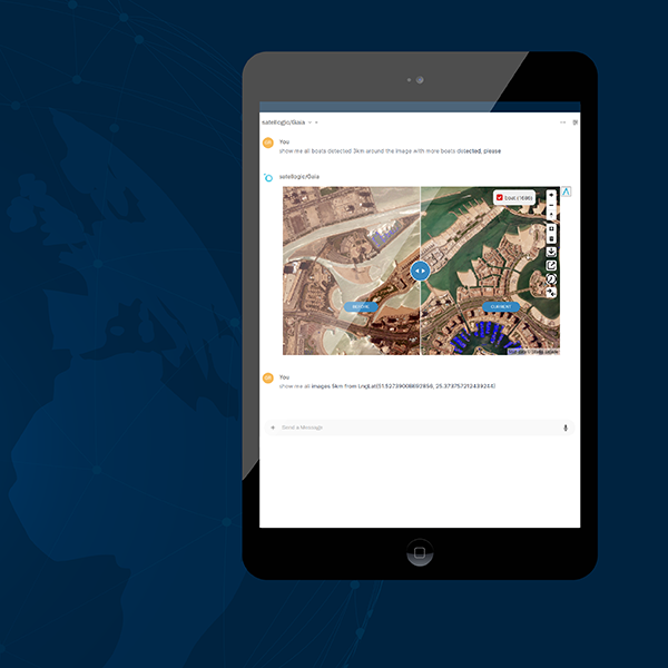
We’re not just delivering AI-enabled analytics from high-resolution imagery—we’re redefining Earth observation with the first AI-first satellites, built to process and deliver insights directly from orbit
Earth observation has traditionally followed a predictable pattern: satellites capture images from space, transmit them to ground stations during available communication windows, and only then can processing begin to extract insights. This workflow creates inherent delays between observation and action. At Satellogic, we are pioneering a transformative approach by embedding artificial intelligence directly within our satellites to revolutionize how we observe, analyze, and respond to our changing planet.
Reimagining Satellite Design: AI-First vs. AI-Enabled
The concept of an “AI-First” satellite represents a fundamental shift in space technology design philosophy. Satellites designed with an “AI-First” philosophy signify a paradigm shift in the way space technology is conceptualized and engineered.Traditional satellites are constructed primarily around their imaging capabilities, with processing power and intelligence considered secondary features or afterthoughts. These conventional systems are essentially sophisticated cameras in space, designed to collect and transmit as much raw data as possible for ground-based processing.
Our AI-First approach reconsiders satellite architecture from first principles. Rather than designing a satellite and then determining how to incorporate AI capabilities, we begin with the AI use cases and requirements, then build the entire satellite architecture to optimize those capabilities. This means every aspect of the satellite—from power systems and thermal management to communications infrastructure and physical layout, computing and on-board APIs—is engineered specifically to support advanced onboard intelligence.
This paradigm shift yields satellites that don’t merely capture images but actively interpret them, identifying patterns, anomalies, and objects of interest in real-time. The distinction is similar to the difference between a conventional camera that simply records everything in its field of view and a smart security system that can distinguish between normal activity and potential threats, only alerting you when something requires attention.
The Evolution of Edge Computing in Space
The fundamental challenges of Earth observation include managing enormous volumes of data, most of which may not contain actionable insights. When capturing wide-swath imagery across vast regions such as oceans, forests, or agricultural lands, only a small percentage typically contains the specific phenomena or changes that users need to identify.
Our AI First satellite technology moves computation directly to the edge, onboard the satellite itself, where powerful GPUs process imagery in real-time as it’s captured. This represents a continuation of Satellogic’s extensive 13-year history of flying advanced GPUs in space, now evolving to support advanced AI workloads at an unprecedented scale.
The new design features a very wide swath sensor specifically engineered to enable daily revisits with a minimal satellite constellation. By continuously capturing imagery across this expanded field of view and processing it immediately using onboard computing resources, we can monitor changes and detect anomalies across the globe with unprecedented frequency.
Technical Architecture for Onboard Intelligence
The technical implementation of our AI First satellite includes several critical components:
Continuous Capture Pipeline: The satellite’s imaging system continuously collects data across its wide swath. Rather than storing and batch processing this data, a real-time analysis pipeline examines every frame as it’s captured.
Onboard GPU Computing: We’ve significantly upgraded the satellite’s computing hardware to process the continuous image stream without bottlenecks. This processing power allows full-resolution analysis of imagery without downsampling or other quality compromises.
Intelligent Data Management: The system includes substantial onboard storage, maintaining a rolling archive of recent captures (several days worth of imagery) to enable retrospective analysis. This allows users to request specific image segments after the fact if events of interest are identified through other means.
Flexible Algorithm Deployment: The computing architecture supports multiple AI models running simultaneously, from basic anomaly detection to complex object recognition. These can be updated or replaced as mission requirements evolve.
Why Onboard AI Creates Transformative Capabilities
This architectural approach delivers several distinct advantages over traditional satellite systems. Latency reduction stands as perhaps the most significant benefit, particularly when detecting time-sensitive events like wildfires in California, illegal construction in protected rainforests, or unauthorized activity in regulated areas. In these scenarios, minutes or hours can make the difference between effective intervention and irreversible damage. By processing imagery onboard and immediately transmitting alerts or priority data, response times shrink from days to minutes. Instead of waiting for full imagery downloads during the next ground station pass (which might be hours away), critical insights can be delivered via low-bandwidth communications channels in near real-time.
Bandwidth optimization represents another crucial advantage, as satellite communications remain a significant constraint in Earth observation. With AI selecting only the most relevant data for priority download, these communications become vastly more efficient. Areas showing no activity of interest, such as open water, unchanging forests, or stable infrastructure, can be compressed more aggressively, stored for later download, or even discarded if unnecessary. This intelligent filtering dramatically reduces downlink requirements while preserving all critical information.
Power efficiency also improves with this approach, as solar energy captured in orbit powers the onboard computation, which can be more energy-efficient than transmitting all raw data to Earth and processing it in ground-based data centers. This method aligns with sustainability goals while delivering performance benefits.
Data sovereignty and security receive significant enhancement as well. By processing data onboard and delivering only the extracted insights or relevant imagery segments directly to users, sensitive information never needs to pass through intermediate systems. This creates inherent security advantages for applications where data privacy and sovereignty are critical considerations, allowing organizations to maintain complete control over their data chain.
Implementation for Users and Organizations
Our platform is designed as an open framework that puts intelligence capabilities directly in the hands of users. Algorithmic flexibility forms the foundation of this approach, enabling organizations to choose from pre-trained models optimized for our imagery characteristics or deploy their own specialized algorithms. This allows them to detect exactly what matters for their specific mission without compromising on performance or accuracy. Continuous improvement mechanisms are built into the system architecture, allowing users to download a small percentage of complete imagery automatically for ongoing algorithm training and refinement.
This creates a virtuous cycle where detection accuracy improves over time through regular model updates based on real-world data. Fine-tuning capabilities provide additional efficiency, as rather than requiring complete algorithm replacements, users can upload fine-tuned versions of existing models. This requires minimal bandwidth while maximizing detection accuracy for specific targets or phenomena, making it practical to optimize for unique detection requirements even with limited communications windows. Multi-modal detection extends the platform’s capabilities beyond visual imagery, as our systems can integrate a variety of signal detection from Radio Frequency to sensors and various types of optical imagery. This integration creates correlation opportunities across multiple data sources for advanced pattern recognition, allowing detection of complex activities or anomalies that might not be apparent in any single data stream alone.
Practical Applications Across Industries
This technology supports diverse applications across industries and government functions. Environmental monitoring represents an impactful use case, detecting deforestation events as they occur rather than discovering them days or weeks later. Our systems can identify specific patterns of land clearing, such as the entrance of heavy machinery into protected areas, alerting authorities before extensive damage occurs. Sustainable resource management benefits similarly, as the platform enables monitoring of agricultural practices, water usage, and natural resource extraction with sufficient frequency to identify unsustainable activities before they create systemic problems. By detecting early indicators of resource depletion or misuse, intervention can occur before permanent damage is done.
Infrastructure development monitoring becomes more effective through this approach, identifying unauthorized construction or development in regulated zones, from informal settlements in protected areas to illicit landing strips or extraction operations in remote regions. The ability to detect early stages of prohibited development allows for enforcement actions before substantial investment creates complex legal and humanitarian challenges.
Disaster response capabilities are significantly enhanced, providing near-immediate damage assessments following natural disasters by processing imagery onboard to identify affected areas, compromised infrastructure, and potential hazards without waiting for complete image downloads. This rapid insight enables more effective emergency response resource allocation and planning in the critical first hours after an event.
Building the Foundation for Global Insights
As we launch the industry’s first – AI First satellite constellation, users will gain access to daily observation capabilities powered by edge intelligence. This represents a fundamental shift from traditional approaches where revisit frequency, processing delays, and bandwidth limitations all constrained the practical utility of satellite data.
By integrating advanced AI models directly onboard our satellites, we’re enabling a new paradigm where global observation becomes truly actionable through intelligent, autonomous systems that deliver exactly the information users need, exactly when they need it.
The future of Earth observation lies not just in collecting more imagery, but in extracting meaningful insights at the source, enabling faster response, better resource allocation, and more effective intervention in both commercial and humanitarian contexts.